 Hartlepool Sports & Leisure
- Cinemas, Theatres & Dance Halls
- Musicians & Bands
- At the Seaside
- Parks & Gardens
- Caravans & Camping
- Sport
 Hartlepool Transport
- Airfields & Aircraft
- Railways
- Buses & Commercial Vehicles
- Cars & Motorbikes
- The Ferry
- Horse drawn vehicles
 A Potted History Of Hartlepool
- Unidentified images
- Sources of information
- Archaeology & Ancient History
- Local Government
- Printed Notices & Papers
- Aerial Photographs
- Events, Visitors & VIPs
 Hartlepool Trade & Industry
- Trade Fairs
- Local businesses
- Iron & Steel
- Shops & Shopping
- Fishing industry
- Farming & Rural Landscape
- Pubs, Clubs & Hotels
 Hartlepool Health & Education
- Schools & Colleges
- Hospitals & Workhouses
- Public Health & Utilities
- Ambulance Service
- Police Services
- Fire Services
 Hartlepool People
 Hartlepool Places
 Hartlepool at War
 Hartlepool Ships & Shipping

Bell Terrace
Details about Bell Terrace
Terrace running from Stockton Street to continue as Villers Street.
Location
Related items :
 Bell Terrace
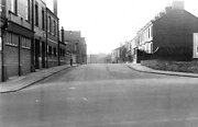 Created by West Hartlepool Council
Part of the Library collection
Created by West Hartlepool Council
Part of the Library collectionDated 1956
Taken from Stockton Street with the Salvation Army HQ on the left. THe first street off on the left is Fawcett Street and on the right at the end of the terrace of houses is Swainson Street.
The road continues into Villiers Street.
The photo was from a photographic record of the Central Area of West Hartlepool prepared in 1955/6 at the request of the Town Planning and Redevelopment Committee 'in the hope that it will be of interest to future generations of West Hartlepool'
The record focuses on areas which were within the next ten years to be completely redeveloped following The Max Lock Plan. It was compiled by WL Taylor and photographs developed by Thomas Clarkson Chemist of Tower Street.
More detail » Demolition of Bell Terrace
 Donated by Robert Wood Collection
Part of the Hartlepool Museum Service collection
Dated 1967
1967 and taken by Robert Wood,part of the College of Further Education is on the right.
Is this Bell Terrace ? This is most likely and the high building behind Pounders. There were advertising boards at the bottom of Bell Terrace and these appear to be on the right near Stockton Street.
More detail » Fawcett Street
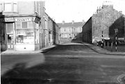 Created by West Hartlepool Council
Part of the Hartlepool Library Collection collection
Created by West Hartlepool Council
Part of the Hartlepool Library Collection collectionDated 1956
Fawcett Street was the last street off Park Road parallel to Stockton Street. The picture has been taken from Park Road looking towards Bell Terrace and the large shadow is of the Central Stores.
The photo was from a photographic record of the Central Area of West Hartlepool prepared in 1955/6 at the request of the Town Planning and Redevelopment Committee 'in the hope that it will be of interest to future generations of West Hartlepool'
The record focuses on areas which were within the next ten years to be completely redeveloped following The Max Lock Plan. It was compiled by WL Taylor and photographs developed by Thomas Clarkson Chemist of Tower Street.
More detail » From College roof 1968 (1)
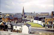 Created by Harry Elliott
Donated by Russell McAndrew
Created by Harry Elliott
Donated by Russell McAndrewDated 1968
Taken in 1968 from the then new College of Further Education roof, the very vast majority of this scene is so very different today. On the far left is the Coop Central Stores building which remains as Park Towers apartments. In the middle distance with the square tower is St George's Church, now the United Reform Church.
The church with the spire is St John's Presbyterian Church in Park Road and now the site is an entrance to the shopping centre near TJ Hughes.
Stockton Street runs across the centre of the photo and this of course was before it was a busy dual carriageway. The street running diagonally with advertising hoardings on the corner is Bell Terrace and the large red building opposite the grassed area is the Salvation Army hall. The street at the bottom running towards Stockton Street is Arthur Street although the houses in that and the other 'A' streets will have been demolished to make way for the college.
More detail » Premier Hotel Bomb Damage
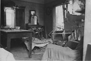 Donated by Hartlepool Museum Service
Dated 1940
Premier Commercial & Temperance Hotel on the corner of Stockton Street & Bell Terrace. This shows what is left of one of the bedrooms after an air raid in August 1940. The hotel was demolished in 1950.
More detail » Premier Hotel Bomb Damage
 Donated by Hartlepool Museum Service
Dated 1940
Damage to the back of the Premier Commercial & Temperance Hotel on the corner of Stockton Street & Bell Terrace after an air raid on 28 August 1940.
More detail » Salvation Army HQ Bomb Damage
 Donated by Hartlepool Museum Service
Dated 1940
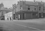
Salvation Army Headquarters on the corner of Stockton Street & Bell Terrace.
More detail » Temperance Hotel and Salvation Army
 Part of the Hartlepool Museum Service collection
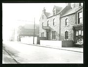
The image shows the Premier Commercial and Temperance Hotel in Stockton Street with Bell Terrace off to the right. Next to it is a grocery department of Hartlepools Co-op. On the other side of Bell Terrace is the Salvation Army Citidal and in the distance, the Central Stores.
HHT&N 200
More detail »


