Hartlepool Sports & Leisure
Hartlepool Transport
A Potted History Of Hartlepool
Hartlepool Trade & Industry
Hartlepool Health & Education
Hartlepool People
Hartlepool Places
Hartlepool at War
Hartlepool Ships & Shipping
Avenue Road, Hartlepool.
Avenue Road
Donated by Robert Wood CollectionTaken from the site where the Labour Exchange was to be built . The houses are little changed today although some are offices.
More detail »
Avenue Road 1960
Created by NDM
Donated by Hartlepool museum serviceWorld Refugee Parade in April 1960 which was led by Hartlepool Scooter Club. On the right is Robinson's garage which was on the corner of Avenue Road and South Road. The King John's Tavern is approximately on the site today. On the left of the photo behind the crowd is Victory Square. This part of Avenue Road was demolished to make. way for Middleton Grange shopping centre. Beyond Avenue Road was Thornton Street and the large buildings in the background are probably in Villiers Street and Park Road.
According to Hartlepool Mail, the parade was organised by Evelyn Harrison of Hartlepool Lonely Hearts Club.
More detail »
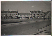
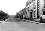
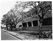
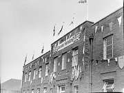
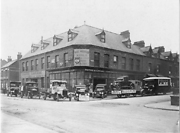
Avenue Road looking north from Villiers Street
Created by West Hartlepool Council
Part of the Library collectionVictory Square can be seen in the right distance where the trees are.
Thornton Street runs right to left beyond the Coop Dairy on the right.
Just beyond Thornton Street, the higher building on the left had originally been Avenue Road School and then the Technical School Annexe.
The photo was from a photographic record of the Central Area of West Hartlepool prepared in 1955/6 at the request of the Town Planning and Redevelopment Committee 'in the hope that it will be of interest to future generations of West Hartlepool'
The record focuses on areas which were within the next ten years to be completely redeveloped following The Max Lock Plan. It was compiled by WL Taylor and photographs developed by Thomas Clarkson Chemist of Tower Street.
More detail »
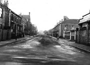
Avenue Road looking south from Victoria Road
Created by West Hartlepool Council
Part of the Library collectionOn the right of the image is what had been Coverdale's School of Commerce but appears to be for sale and was to become Perry's TV and Radio for many years before being various wine bars. Victory Square is on the left and on the next corner on the right is Robinson's Garage. Villiers Street is in the distance.
The photo was from a photographic record of the Central Area of West Hartlepool prepared in 1955/6 at the request of the Town Planning and Redevelopment Committee 'in the hope that it will be of interest to future generations of West Hartlepool'
The record focuses on areas which were within the next ten years to be completely redeveloped following The Max Lock Plan. It was compiled by WL Taylor and photographs developed by Thomas Clarkson Chemist of Tower Street.
More detail »
Avenue Road now
Donated by Harry TaylorA picture of Avenue Road, Hartlepool as it was untilo a couple of months ago. The Corner House has been replaced by Shearas fish and chip shop.
More detail »
Avenue Road then (2)
Donated by Mr. Harry TaylorWhat remains of the south section of Avenue Road, Hartlepool. Perry Tv and Radio on the right.
More detail »
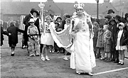
Cenotaph and house clearances
Created by Robert Wood
Donated by Robert Wood CollectionTaken from South Road, looking across Avenue Road towards Binns clearly on the left and the cenotaph. The massive house clearance programme has obliterated Hanover Street,Wesley Street, Peckett Street and Swainson Street and much of where these streets were is the market part of Hartlepool Shopping Centre and the shops behind the cenotaph. Taken by Robert Wood in 1967.
More detail »
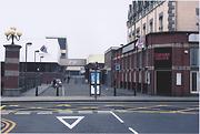
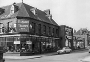
Civic Centre Avenue Road
Donated by Douglas FerridayThe side of the Civic Centre in Avenue Road, Hartlepool. The Courts are in the first section. The Probation Service in the secons and the Police Station is the last new section.
More detail »
Coronation Procession (1)
Created by unknown
Donated by Edw.G.WattThe Coronation Carnival Queen, escorted by her attendants, in Lauder Street on 12th May, 1937. This view is taken looking west to Avenue Road.
HHT+N 29
More detail »
Coronation Procession (3)
Created by unknown
Donated by Edw.G.WattCoronation Carnival Parade in Lauder Street looking up to Avenue Road. The Blind School is just visible in the background and the back of the Regal cinema beyond. Patriotic ladies are encouraging people to buy British produce. He must be worn out doing a handstand for that length of time. 12th May 1937.
HHT+N 3
More detail »
Coronation Procession (4)
Created by unknown
Donated by Edw.G.WattTwo ladies, possibly from the Match Factory, as the adverts on their bicycles read Nemco and Coronation matches in the Coronation parade. This view is taken looking east on Lauder Street. The Technical College can be seen on the right with the Town Hall behind - opposite on the left hand side is the Masonic Hall. The Pearly King on the left of the picture has his bicycle decorated with pictures of the Royal family. 12th May 1937.
HHT+N 4
More detail »
Finance Department Avenue Road
Created by NDM
Donated by Hartlepool Museum ServiceTaken in 1953, the image shows West Hartlepool Finance Office in Avenue Road decorated for the Coronation of Elizabeth the second.
More detail »
Opening of Workshops for the Blind
Part of the Hartlepool Museum Service collectionThe Workshops were opened by the Mayoress for West Hartlepool Mrs JW Wilson, £3000 of the funding was raised by her.
More detail »
Ox Roast
Donated by Douglas FerridayPicture of an ox roast in Hartlepool. The building behind it is now Hartlepool People's Centre and was originally the Police Station. The ox roasting took place on the land in Raby Road/ Avenue Road where the Labour Exchange was built and the view of the building is the Tees Street side.
HHT+N 364
More detail »
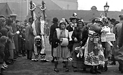
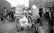
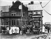
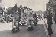
Playscheme Children in Avenue Road
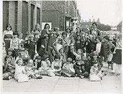
Created by Hartlepool Mail
Donated by Hartlepool Museum ServiceThis is one of a number of photos in the Museum files of children on a summer playscheme at various venues in 1980. Here the children appear to be waiting for a bus perhaps. Errol Street is on the right behind the children and the building which had been The Workshops for the Blind on the left have been replaced by a terrace of new shops.
More detail »
Robert Robinson - Motor & Cycle Engineers & Factors
Donated by Hartlepool Museum ServiceRobert Robinson, Motor & Cycle Engineers & Factors, with the Grand Garage adjacent.
HHT+N 752
More detail »
Robert Robinson's Garage
Donated by Hartlepool Library ServiceRobert Robinson's Garage, Avenue Road. The showrom on the right was added in 1960. Note the Triumph motor car with the reg no EF 4 parked there.
Sid Robinson also owned EF2 which was the original number plate of his father's De Dion.
HHT&N 687
More detail »
Robert Robinson's garage
Donated by Hartlepool Museum ServiceA range of 'Vulcan' vehicles displayed around Robert Robinson's premises. Cars are priced at £295 and lorries range from £445 to £545.
The houses on the left were demolished to ake way for a showroom extension in 1960.
More detail »
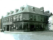
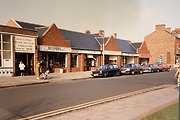
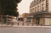
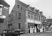
Skyy Nightclub - Lounge - Wine bar
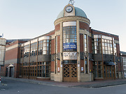
Created by Don Stephenson
Donated by Don StephensonA Nightclub · Lounge · Wine bar in Avenue Road, Hartlepool, formerly called Time & Tide.
More detail »