 Hartlepool Sports & Leisure
- Cinemas, Theatres & Dance Halls
- Musicians & Bands
- At the Seaside
- Parks & Gardens
- Caravans & Camping
- Sport
 Hartlepool Transport
- Airfields & Aircraft
- Railways
- Buses & Commercial Vehicles
- Cars & Motorbikes
- The Ferry
- Horse drawn vehicles
 A Potted History Of Hartlepool
- Unidentified images
- Sources of information
- Archaeology & Ancient History
- Local Government
- Printed Notices & Papers
- Aerial Photographs
- Events, Visitors & VIPs
 Hartlepool Trade & Industry
- Trade Fairs
- Local businesses
- Iron & Steel
- Shops & Shopping
- Fishing industry
- Farming & Rural Landscape
- Pubs, Clubs & Hotels
 Hartlepool Health & Education
- Schools & Colleges
- Hospitals & Workhouses
- Public Health & Utilities
- Ambulance Service
- Police Services
- Fire Services
 Hartlepool People
 Hartlepool Places
 Hartlepool at War
 Hartlepool Ships & Shipping

Musgrave Street
Details about Musgrave Street
Musgrave Street has now been demolished and replaced by a modern housing estate.
Location
Related items () :
 Brunswick West Hartlepool
 Donated by Hartlepool Library Service
Part of the Hartlepool Public Houses collection
Public house on the corner of Musgrave Street and Brunswick Street which opened in 1856 and closed in 1969. In the 1940s, it was known as 'The Blood Bath' because of the numerous fights !
(from Lion Roars and Monkey Bites by Marie- Louise McKay)
More detail » Burbank Street/ Musgrave Street area
 Part of the Hartlepool Museum Service collection
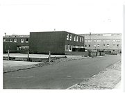
Following the demolition of Victorian terraces and shops, a new estate was built in 1969 between these two streets around Flamborough Walk (now come and gone)from concrete blocks with walkways between upper levels. This area was never really successful, was demolished and more appealing further housing built.
More detail » Carnival King and Queen (1)
 Created by unknown
Donated by Hartlepool Library Service
Created by unknown
Donated by Hartlepool Library ServiceDated 1925
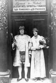
Carnival King & Queen taken outside the Ward Jackson Hotel, Lynn Street/Musgrave Street. The proprietor was Joseph Henry Smith. It is said that when the Carnival was no longer popular he revived it, starting the procession from the door of the pub in 1925.
HHT+N 204
More detail » Central Hotel Bomb Damage
 Created by F.C. Huntley
Donated by Hartlepool Museum Service
Created by F.C. Huntley
Donated by Hartlepool Museum ServiceDated 1940
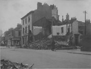
Central Hotel on the corner of Musgrave & Brunswick Streets after it was hit during the air raid on 20 August 1940.
HHT&N 47
More detail » Harris Store corner of Whitby/ Musgrave Street
 Part of the Hartlepool Museum Service collection
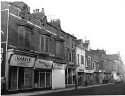
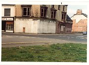
Just as it was to be demolished in the mid 1970s, the image shows Harris's which sold linens, curains , bedding etc and Gents firearm dealers on the corner of Musgrave Street and Whitby Street.
The B on the side wall is a remnant of Birks Brothers as the building had been a Birks shop and cafe.
More detail » Level Crossing Musgrave Street
 Donated by Robert Wood Collection
Part of the Hartlepool Museum Service collection
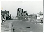
Across Mainsforth Terrace from Musgrave Street, there was a level crossing across the railway into Old Town. The signal box is still there in this picture. The houses were demolished in 1981 having replaced the original Old Town housing.
More detail » Mr Farrar Fish Buyer
 Donated by Hartlepool Museum Service
Part of the David Wise collection
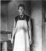
Fish shop owner. Originally had a shop in Musgrave Street.
More detail » Musgrave St 1964
 Part of the Hartlepool Museum Service collection
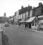
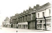
Looking towards Lynn Street in 1964, Lithgow's Pram shop is on the right and at the cross roads with Lynn Street is the Ward Jackson Hotel.
More detail » Musgrave St- Grafton's
 Part of the Hartlepool Museum Service collection
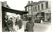
A busy scene in Musgrave street in the 1960s. The number 4 bus has just turned into Lynn Street, Grafton's dress shop seems to have a delivery and the Ward Jackson pub is on the right hand corner. In the background and over the railway, the houses in South Street Old Town can be seen.
More detail » Musgrave Street
 Created by Bill Boagey
Donated by Hartlepool Museum Service
Created by Bill Boagey
Donated by Hartlepool Museum ServicePart of the Bill Boagey collection
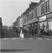
Looking West from Lynn Street. The picture shows a good range of shops. Charles Dickens Tool shop can be seen on the right.
More detail » Musgrave Street
 Donated by Hartlepool Museum Service
Shops in Musgrave Street boarded up.
More detail » Musgrave Street
 Donated by Glenis Brown
Musgrave Street with view of Co-op building at the end.
More detail » Musgrave Street 1955
 Created by West Hartlepool Council
Part of the Library collection
Created by West Hartlepool Council
Part of the Library collectionDated 1955
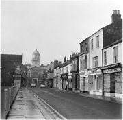
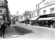
The two men on the left are on the corner of Park Street and the next street on the left with Ward Jackson School beyond is Rokeby Street. On the right, the street visible between the terrace of shops is York Street. The view taken in 1955 looks towards The Central Stores.
The photo was from a photographic record of the Central Area of West Hartlepool prepared in 1955/6 at the request of the Town Planning and Redevelopment Committee 'in the hope that it will be of interest to future generations of West Hartlepool'
The record focuses on areas which were within the next ten years to be completely redeveloped following The Max Lock Plan. It was compiled by WL Taylor and photographs developed by Thomas Clarkson Chemist of Tower Street.
More detail » Musgrave Street 1960
 Part of the Hartlepool Museum Service collection
Dated 1960
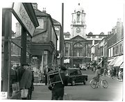
Looking up towards the Central Stores in Stockton Street. Warwick Place is on the left.
More detail » Musgrave Street 1968
 Created by Douglas Ferriday
Donated by HLS
Created by Douglas Ferriday
Donated by HLSDated 1968
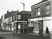
North side of Musgrave Street, probably at junction with York Street.
More detail » Musgrave Street 1978
 Part of the Douglas Ferriday collection
Dated 1978
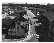
Taken from the Central Stores tower, the view is looking down Musgrave Street which has virtually been cleared. In the middle distance is the Spotted Cow pub which at this time was called The Square Ring. Hucklehoven Way slightly to the left of Musgrave Street replaced the original street.
HO4098
More detail » Musgrave Street Hartlepool then and now
 Created by Bill Stevenson
Donated by Hartlepool Library Service
Created by Bill Stevenson
Donated by Hartlepool Library ServiceMusgrave Street, Hartlepool showing Birmingham House of Robinsons Store.
More detail » Musgrave Street bomb damage
 Donated by Douglas Ferriday
Part of the Hartlepool Library Service collection
Dated 1940
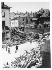
The picture is dated 1940. On 19th- 20th June, the Musgrave St area was badly damaged and it was the first of many raids on the town. Four highly explosive bombs were dropped on the area and amazingly only one man and one woman were killed although there were many more injured. Four shops, six houses and the Central Hotel were completely demolished and 30 shops, 63 homes, one pub and St Joseph's School were badly damaged. Over 100 other buildings were damaged.
HHT&N 46
More detail » Musgrave Street from Scarborough Street
 Created by West Hartlepool Council
Part of the Library collection collection
Created by West Hartlepool Council
Part of the Library collection collectionDated 1955
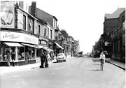
Taken in 1955 looking east along Musgrave Street from Scarborough Street. The World War 2 bomb damaged old St Joseph's School is on the right and St James' Church on the corner of Whitby Street can be seen on the left.
The photo was from a photographic record of the Central Area of West Hartlepool prepared in 1955/6 at the request of the Town Planning and Redevelopment Committee 'in the hope that it will be of interest to future generations of West Hartlepool'
The record focuses on areas which were within the next ten years to be completely redeveloped following The Max Lock Plan. It was compiled by WL Taylor and photographs developed by Thomas Clarkson Chemist of Tower Street.
More detail » Musgrave Street looking west
 Created by Douglas Ferriday
Donated by Hartlepool Library Service
Created by Douglas Ferriday
Donated by Hartlepool Library ServiceDated 1970
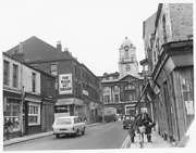
Musgrave Street, looking towards the Co-Op building, in 1970. Musgrave Street has since been demolished.
More detail » Musgrave Street looking west 1955
 Created by West Hartlepool Council
Part of the Library collection
Created by West Hartlepool Council
Part of the Library collectionDated 1955
Taken in 1955, looking west from South Scarborough Street, Rosen's is on the corner of Tower Street and Teesside Farmers on the left. Ward Jackson School is also on the left and the Central Stores in the distance.
In the foreground is a builder's hut where work on the new St Joseph's Primary School has just begun.
The photo was from a photographic record of the Central Area of West Hartlepool prepared in 1955/6 at the request of the Town Planning and Redevelopment Committee 'in the hope that it will be of interest to future generations of West Hartlepool'
The record focuses on areas which were within the next ten years to be completely redeveloped following The Max Lock Plan. It was compiled by WL Taylor and photographs developed by Thomas Clarkson Chemist of Tower Street.
More detail » Musgrave Street/ Brunswick Street
 Part of the Hartlepool Museum Service collection
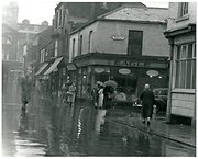
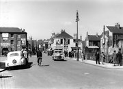
Taken in the late 1950s on a very rainy day, The Central Stores can be seen at the top of the street and The Brunswick on the corner of Brunswick Street.
More detail » Musgrave Street/ Lynn Street corner
 Donated by Hartlepool Museum Service
Part of the Hartlepool Museum Service collection
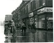
Taken on a rainy day in the late 1950s, the image shows a No.4 Corporation bus which would turn along into Lynn Street and finally weave its way to Thornhill Gardens (as on destination board), having come from Rift House.
The Benefit Shoe shop is on the corner of Lynn Street and into Musgrave Street is Ernest Wilson, Charles Dickens Tool Store and The Piccadilly Bar. Charles Dickens was one of the last buildings in the area to be finally demolished in 1978 and was the last to trade in the area.
More detail » Musgrave and Queen Streets Bomb Damage
 Dated 1940
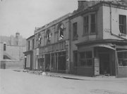
Showing damage to the furniture store & Oliver's Fish Shop (on the corner) after being bombed during an air raid in June 1940. St Joseph's School can be seen in the background
More detail » Piccadilly Ice Cream
 Created by unknown
Donated by Eva Smith
Created by unknown
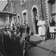
Donated by Eva SmithEva Amerigo (left), Mary Hogan and her daughter Nellie, in Musgrave Street in the 1950s.
More detail » Rear of terraced buildings in Musgrave Street (?)
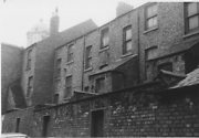 Donated by Hartlepool Museum Service
Rear of terraced buildings in Musgrave Street (?) with the Central Stores Dome in the background
More detail » Robinson Leather Merchant
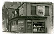 Part of the Hartlepool Museum Service collection
The shop was at 68 Musgrave Street and on the corner of Musgrave Street and South Scarborough Street on the left.
More detail » Robinson's Birmingham House demolition
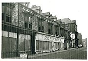 Donated by Elizabeth Law
Part of the Hartlepool Museum Service collection
Taken during demolition, the image is taken in Musgrave Street looking west towards the Central Stores. To the right of Robinson's Lithgow's Pram Shop can just be seen.
More detail » Robinson's Birmingham House demolition 2
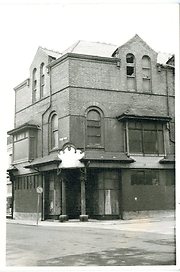 Created by Elizabeth Law
Donated by Elizabeth Law
Created by Elizabeth Law
Donated by Elizabeth LawPart of the Hartlepool Museum Service collection
Boarded up and awaiting demolition.
More detail » Robinsons Birmingham House
 Donated by Douglas Ferriday
Part of the Library collection collection
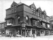
Birmingham House opened in 1913 as part of Matthias Robinson's empire in West Hartlepool. It was on the corner of Whitby Street and Musgrave Street(the street sign is on the building). This part of the store advertises Bedding, Bedsteads, Upholstery and Furniture.
Trolley bus lines can clearly be seen in the picture.
Next to this part of the store to the left of the picture is Lithgow's Pram Shop in Musgrave Street.
HHT+N 778
More detail » St James' Church
 Donated by Douglas Ferriday
Part of the Hartlepool Library Service collection
Dated 1900
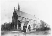
St James' Church, Musgrave Street, circa 1900
More detail » St James' Church
 Donated by Hartlepool Museum Service
St James' Church, Musgrave Street, Hartlepool c1900.
More detail » St James' Church 1955
 Created by West Hartlepool Council
Part of the Library collection
Created by West Hartlepool Council
Part of the Library collectionDated 1955
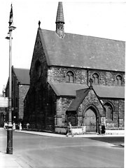
The church, which opened in 1870, was on the corner of Whitby Street and Musgrave Street. Anew St James' Parish was formed and a new church built in Rossmere Way. The old St James' was demolished in 1956/7.
The photo was from a photographic record of the Central Area of West Hartlepool prepared in 1955/6 at the request of the Town Planning and Redevelopment Committee 'in the hope that it will be of interest to future generations of West Hartlepool'
The record focuses on areas which were within the next ten years to be completely redeveloped following The Max Lock Plan. It was compiled by WL Taylor and photographs developed by Thomas Clarkson Chemist of Tower Street.
More detail » St Joseph's School 1955
 Created by West Hartlepool Council
Donated by Hartlepool Library Service
Created by West Hartlepool Council
Donated by Hartlepool Library ServicePart of the Library collection
Dated 1955
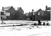
The view is the site of St Joseph's School just as it is to be built. Workwear Supplies is on the corner of Musgrave Street and Scarborough Street. On the other side of Musgrave Street, the bomb damaged first St Joseph's School can be seen and the large building behind is the Co-op Whitby Street premises.
The photo was from a photographic record of the Central Area of West Hartlepool prepared in 1955/6 at the request of the Town Planning and Redevelopment Committee 'in the hope that it will be of interest to future generations of West Hartlepool'
The record focuses on areas which were within the next ten years to be completely redeveloped following The Max Lock Plan. It was compiled by WL Taylor and photographs developed by Thomas Clarkson Chemist of Tower Street.
More detail » The Circus is in Town
 Donated by Douglas R.P.Ferriday
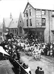
Sangers Circus passing along Musgrave Street to the delight of the crowds.In the background is Ward Jackson School next to (possibly J. Wilson's ?) Boot Palace on the corner.
Thispicture possibly dates from 1886 when Sangers Circus undertook a huge tour with West Hartlepool being the most Northerly call.
A popular song of the time detailing the tours was popular with the West Hartlepool section being mentioned as
"West Hartlepool was rather cool"
but they tried to our monkey's"
HHT+N 13
More detail » The Ward Jackson Hotel in Lynn Street
 Donated by Douglas Ferriday
Part of the Hartlepool Library Service collection
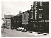
Although there is a pub of the same name now in Church Square, the Ward Jackson Hotel on this image was on the east corner of Lynn Street and Musgrave Street. The photo will have been taken in the late 1960s/early 1970s prior to demolition.
HHT&N 784
More detail » Tom Brown
 Donated by Hartlepool Library Service
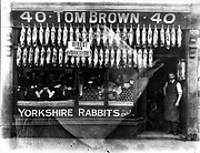
This would appear to be a grocery store which was at 40 Musgrave Street, Hartlepool. Little else is known, unfortunately. The sign in the window indicates that he sold Yorkshire Rabbits only.
The picture is damaged in so much that there has been a horses head superimposed onto it.
HHT&N 182
More detail » Walker's Butcher
 Created by NDM
Donated by Hartlepool Museum Service
Created by NDM
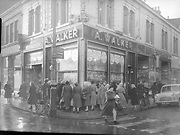
Donated by Hartlepool Museum ServiceThis was taken in the early 1950s on the corner of Musgrave St and Lynn St. Next to Walkers on the Musgarve St side is The Fruit Market. A few years later, this shop became part of Grafton's Fashions which can just be seen on te far right.
On the Lynn St side are Tom Richardson and what looks to be a chemist's shop selling Virol.
More detail » Ward Jackson School
 Created by West Hartlepool Council
Part of the Library collection
Created by West Hartlepool Council
Part of the Library collectionDated 1955
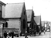
The original school in Musgrave Street opened in 1877 and was replaced by the current school in Clarke Street in 1968. This photo was taken in 1955 and the building was demolished in 1969.
The photo was from a photographic record of the Central Area of West Hartlepool prepared in 1955/6 at the request of the Town Planning and Redevelopment Committee 'in the hope that it will be of interest to future generations of West Hartlepool'
The record focuses on areas which were within the next ten years to be completely redeveloped following The Max Lock Plan. It was compiled by WL Taylor and photographs developed by Thomas Clarkson Chemist of Tower Street.
More detail »


