 Hartlepool Sports & Leisure
- Cinemas, Theatres & Dance Halls
- Musicians & Bands
- At the Seaside
- Parks & Gardens
- Caravans & Camping
- Sport
 Hartlepool Transport
- Airfields & Aircraft
- Railways
- Buses & Commercial Vehicles
- Cars & Motorbikes
- The Ferry
- Horse drawn vehicles
 A Potted History Of Hartlepool
- Unidentified images
- Sources of information
- Archaeology & Ancient History
- Local Government
- Printed Notices & Papers
- Aerial Photographs
- Events, Visitors & VIPs
 Hartlepool Trade & Industry
- Trade Fairs
- Local businesses
- Iron & Steel
- Shops & Shopping
- Fishing industry
- Farming & Rural Landscape
- Pubs, Clubs & Hotels
 Hartlepool Health & Education
- Schools & Colleges
- Hospitals & Workhouses
- Public Health & Utilities
- Ambulance Service
- Police Services
- Fire Services
 Hartlepool People
 Hartlepool Places
 Hartlepool at War
 Hartlepool Ships & Shipping

Burbank Street
Details about Burbank Street
Burbank Street, Hartlepool
Location
Related items :
 Band in Rokeby Street
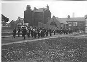 Donated by Margaret Foster
Here the Salvation Army band are marching along a demolished Rokeby Street from Burbank Street. The houses of Burbank Street are in the background and most of these are still there today. Stranton Mission Church in the centre is now a convenience store.
The new Ward Jackson School and bungalows stand on the empty land now.
More detail » Band in Burbank Street (1)
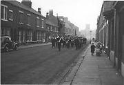 Donated by Mrs Nichol
The Band in Burbank Street looking towards Stranton Church in the distance. Looking at the cars and children, this is probably mid 1950s.
The houses on the right were renovated some years ago but now look as if further renovation is due.
More detail » Burbank Street
 Part of the Library collection collection
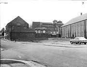
The image shows the back of the Gaumont cinema (later Fairworld Bingo) on the right and this is now demolished. Cameron's Brewery is clearly visible, as are the offices with the white bay windows. On the left is the Foster and Armstrong building which is now demolished. Currently much ofthis land is vacant although the Royal Mail office is now at the far right.
HHT&N 199
More detail » Burbank Street 1961
 Part of the Hartlepool Museum Service collection
Dated 1961
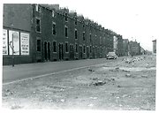
Taken in 1961 according to the reverse, one side of the Mainsforth Terrace end of Burbank Street had already been demolished. Note the advert for Hartlepool Carnival. Newburn School can be seen at the end of the terrace.
More detail » Burbank Street Methodist Chapel
 Donated by Hartlepool Museum Service
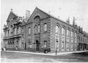
Burbank Street Methodist Chapel was built in 1868.
Also shows school & a house attached to the church. A sign on the front of the school says H&A Percy Watson.
More detail » Burbank Street United Methodist Chapel
 Donated by Douglas Ferriday
Part of the Hartlepool Library Service collection
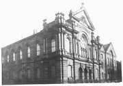
The original Burbank Street UM Chapel was to the right of this 1875 building and was used as a Sunday School. This large church seated 1,100 people and cost £10,000 to build. It was severely damaged by a Zeppelin raid in March 1918.
More detail » Burbank Street area
 Part of the Hartlepool Museum Service collection
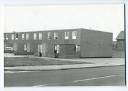
In the area between Burbank Stree, Whitby Street and Musgrave Street, many homes were built in the 1960s from huge concrette slabs and a system of pathways and first floor walkways ran between them. This was never really successful and the homes have since been rebuilt or massively renovated.
More detail » Burbank Street now
 Donated by Harry Taylor
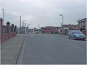
Looking west up Burbank Street, Hartlepool, towards Stranton Church. The fence was originally from Newburn School.
More detail » Burbank Street then
 Donated by Mr. Harry Taylor
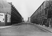
Dated 1955
Looking along Burbank Street with All Saints (Stranton) Church in the far distance and dated 1955.
From a collection of photos commissioned and gathered by West Hartlepool Council.
HHT+N 699
More detail » Burbank Street then (1955)
 Donated by Mr. Harry Taylor
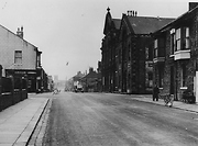
Dated 1955
A different view along Burbank Street looking towards All Saints (Stranton) Church. On the right are the two huge Burbank Street Methodist Chapels built in 1868 and 1875.
From a collection of photos commissioned and gathered by West Hartlepool Council.
More detail » Burbank Street then (2)
 Donated by Harry Taylor
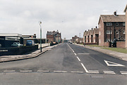
Burbank Street from several years ago when the Bridge Youth Centre was still standing. This is the large detached building on the left.
More detail » Burbank Street/ Musgrave Street area
 Part of the Hartlepool Museum Service collection
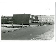
Following the demolition of Victorian terraces and shops, a new estate was built in 1969 between these two streets around Flamborough Walk (now come and gone)from concrete blocks with walkways between upper levels. This area was never really successful, was demolished and more appealing further housing built.
More detail » Clarke Street
 Donated by Hartlepool Library Service
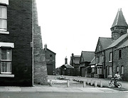
Clarke Street, Burbank Street junction, Hartlepool. Old Fire Station in background
More detail » Demolition of Burbank St Methodist Church
 Created by NDM
Donated by Hartlepool museum service
Created by NDM
Donated by Hartlepool museum serviceDated 1959
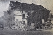
Taken in September 1959. The church hall had already been demolished.
More detail » Emma and her dad
 Donated by Mr. John Brooker
Dated 1929
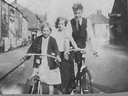
Emma Herring and her Dad on their bicycles in Burbank Street in 1929. The lady may be Mrs. Harker.
More detail » Foster & Armstrong Anchor Mills
 Part of the Hartlepool Museum Service collection
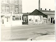
Probably taken in the early 1960s, the image shows Anchor Mill(demolished 1980) on the left (later images show it without windows at street level. Betwen the mill and the advertising boards was the entrance from Stockton Street to Burbank Street. On the right in Thompson Street, the large warehouse belonged to the Co-op and this still exists as amongst other things car repair garages. The imposing Durham Paper Mill chimney, which was illuminated in red letters at night, can clearly be seen. This was demolished in 1971.
More detail » Foster & Armstrong Anchor Mills
 Donated by Hartlepool Museum Service
Shop for 'Gardens and pets'. Building on corner of Stockton St. & Burbank St. 'for Sale' notices in two of the windows.
More detail » James Street
 Created by West Hartlepool Council
Part of the Library collection
Created by West Hartlepool Council
Part of the Library collectionDated 1955
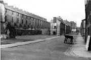
Taken in 1955 looking towards Lynn Street from Mainsforth Terrace. At this point James Street was partly demolished. On the left, the back of the large terraced houses were those in Burbank Street.
The photo was from a photographic record of the Central Area of West Hartlepool prepared in 1955/6 at the request of the Town Planning and Redevelopment Committee 'in the hope that it will be of interest to future generations of West Hartlepool'
The record focuses on areas which were within the next ten years to be completely redeveloped following The Max Lock Plan. It was compiled by WL Taylor and photographs developed by Thomas Clarkson Chemist of Tower Street.
More detail » Junction of Clark Street and Burbank Street - then and now
 Created by Bill Stevenson
Donated by Hartlepool Library Service
Created by Bill Stevenson
Donated by Hartlepool Library ServiceThe original image shows the old Fire Station in Clark Street at the junction with Burbank Street.
More detail » Tombling General Dealer
 Donated by Mrs. Katrina Harper
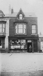
Lily (Livinia) Tombling stands in the doorway of the General Dealer's shop she ran with her husband Joseph from 1923 to 1954 in Burbank Street. Lily was renowned for baking pies. The windows of their shop were blown out by a bomb blast during WWII.
The shop is now a take away, and the left side of the shop is now at the end of a long terrace stretching up to Clark Street. To the right of the shop,a house has possibly been built since this image was taken.
More detail »


