Created by West Hartlepool Council
Donated by Harry Taylor
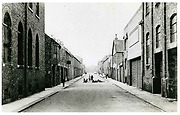
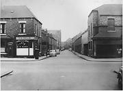
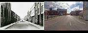
Roker Street, Hartlepool, looking East from Dalton Street across York Road. Roker street is now part of the Town Centre and car parks.
The Coop bakery is on the left and Waldon Street in the distance.
The photo was from a photographic record of the Central Area of West Hartlepool prepared in 1955/6 at the request of the Town Planning and Redevelopment Committee 'in the hope that it will be of interest to future generations of West Hartlepool'
The record focuses on areas which were within the next ten years to be completely redeveloped following The Max Lock Plan. It was compiled by WL Taylor and photographs developed by Thomas Clarkson Chemist of Tower Street.
More detail »


 Hartlepool Sports & Leisure

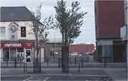
 Roker Street