Home / Relations / Images / Raby Road / Middleton Road
 Hartlepool Sports & Leisure
- Cinemas, Theatres & Dance Halls
- Musicians & Bands
- At the Seaside
- Parks & Gardens
- Caravans & Camping
- Sport
 Hartlepool Transport
- Airfields & Aircraft
- Railways
- Buses & Commercial Vehicles
- Cars & Motorbikes
- The Ferry
- Horse drawn vehicles
 A Potted History Of Hartlepool
- Unidentified images
- Sources of information
- Archaeology & Ancient History
- Local Government
- Printed Notices & Papers
- Aerial Photographs
- Events, Visitors & VIPs
 Hartlepool Trade & Industry
- Trade Fairs
- Local businesses
- Iron & Steel
- Shops & Shopping
- Fishing industry
- Farming & Rural Landscape
- Pubs, Clubs & Hotels
 Hartlepool Health & Education
- Schools & Colleges
- Hospitals & Workhouses
- Public Health & Utilities
- Ambulance Service
- Police Services
- Fire Services
 Hartlepool People
 Hartlepool Places
 Hartlepool at War
 Hartlepool Ships & Shipping

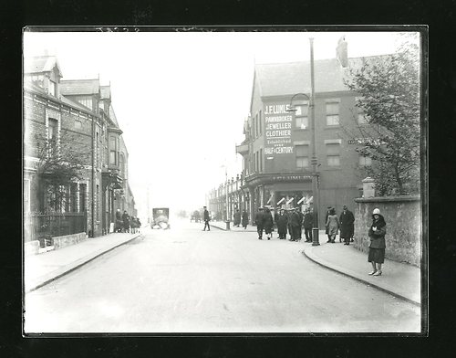
Raby Road / Middleton Road
What we know about this image :
The image appears to be from the 1920s. On the left, in Raby Road is Howbeck Terrace and then after the shop would be Middleton Road. Hart Road Methodist Church is on the other side of Middleton Road. All buildings on the left are now demolished. Raby Road continues towards the town after the crossroads but before 1967 was called Hart Road. On the right is the North Cemetery wall, then Hart Lane. The shops on the right are little changed today.
HHT+N 630
Donor : Douglas Ferriday
Part of the "Hartlepool Library Service" collection
Location
Related items :
 Hart Lane
Hart Lane. The B1376, Hart Lane runs from Raby Road (orignally pre 1967 Hart Road) to Hart Village.
More detail » Hart Road Methodist Church
Methodist church on the corner of Raby Road (formerly Hart Road) and Middleton Road now demolished.
More detail »

Hartlepool History Then & Now
© 2025 Hartlepool Borough Council


