 Hartlepool Sports & Leisure
- Cinemas, Theatres & Dance Halls
- Musicians & Bands
- At the Seaside
- Parks & Gardens
- Caravans & Camping
- Sport
 Hartlepool Transport
- Airfields & Aircraft
- Railways
- Buses & Commercial Vehicles
- Cars & Motorbikes
- The Ferry
- Horse drawn vehicles
 A Potted History Of Hartlepool
- Unidentified images
- Sources of information
- Archaeology & Ancient History
- Local Government
- Printed Notices & Papers
- Aerial Photographs
- Events, Visitors & VIPs
 Hartlepool Trade & Industry
- Trade Fairs
- Local businesses
- Iron & Steel
- Shops & Shopping
- Fishing industry
- Farming & Rural Landscape
- Pubs, Clubs & Hotels
 Hartlepool Health & Education
- Schools & Colleges
- Hospitals & Workhouses
- Public Health & Utilities
- Ambulance Service
- Police Services
- Fire Services
 Hartlepool People
 Hartlepool Places
 Hartlepool at War
 Hartlepool Ships & Shipping

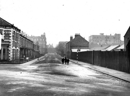
Swainson Street looking north from Thornton Street
What we know about this image :
Looking along Swainson towards Grand Hotel and Raby Road in the background. The house in Thornton Street nearside left is Thornton House (on plaque on wall) Behind the fencing on the right is Messrs F Hills and Co Stockton Street Sawmill and Timber Yard. Binns is just visible on far right.
The photo was from a photographic record of the Central Area of West Hartlepool prepared in 1955/6 at the request of the Town Planning and Redevelopment Committee 'in the hope that it will be of interest to future generations of West Hartlepool'
The record focuses on areas which were within the next ten years to be completely redeveloped following The Max Lock Plan. It was compiled by WL Taylor and photographs developed by Thomas Clarkson Chemist of Tower Street.
Date (of image) : 0/2/1956
Creator : West Hartlepool Council
Part of the "Library" collection
Location
Related items :
 Swainson Street
Swainson Street, Hartlepool. Most of Swainson Street was demolished to make way for Middleton Grange Shopping Centre. The only section left contains The Grand Hotel.
More detail » Thornton Street
Street in Hartlepool which originally ran west from Clifton Avenue, across York Road and down to Stockton Street. The section from York Road to Stockton Street was demolished in the 1960s to make way for the shopping centre and car parking.
More detail »


