 Hartlepool Sports & Leisure
- Cinemas, Theatres & Dance Halls
- Musicians & Bands
- At the Seaside
- Parks & Gardens
- Caravans & Camping
- Sport
 Hartlepool Transport
- Airfields & Aircraft
- Railways
- Buses & Commercial Vehicles
- Cars & Motorbikes
- The Ferry
- Horse drawn vehicles
 A Potted History Of Hartlepool
- Unidentified images
- Sources of information
- Archaeology & Ancient History
- Local Government
- Printed Notices & Papers
- Aerial Photographs
- Events, Visitors & VIPs
 Hartlepool Trade & Industry
- Trade Fairs
- Local businesses
- Iron & Steel
- Shops & Shopping
- Fishing industry
- Farming & Rural Landscape
- Pubs, Clubs & Hotels
 Hartlepool Health & Education
- Schools & Colleges
- Hospitals & Workhouses
- Public Health & Utilities
- Ambulance Service
- Police Services
- Fire Services
 Hartlepool People
 Hartlepool Places
 Hartlepool at War
 Hartlepool Ships & Shipping

Thornton Street
Details about Thornton Street
Street in Hartlepool which originally ran west from Clifton Avenue, across York Road and down to Stockton Street. The section from York Road to Stockton Street was demolished in the 1960s to make way for the shopping centre and car parking.
Location
Related items :
 Earnshaw's baker's van
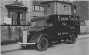 Donated by Hartlepool Museum Service
Earnshaw's Morris Commercial van parked at the Elwick Road end of Osborne Road. The van would have been new in 1945. C Earnshaw Bros. Ltd. were well known in Hartlepool. Their premises were at 5 Thornton Street.
More detail » From College roof (2)
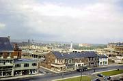 Created by Harry Elliott
Donated by Russell McAndrew
Created by Harry Elliott
Donated by Russell McAndrewDated 1968
Taken in 1968 from the roof of the newly built College of Further Education, this image shows a quickly changing town centre.
Recognisable today are the Cenotaph and to the right of it, the Grand Hotel, both in Victoria Road. Also visible between these two structures is the old Essoldo cinema or Carlton Bingo as it is now. Two church spires can be seen, the one slightly further away is St Paul's in Grange Road and the one slightly closer is the now demolished York Road Methodist Church which was on the corner of South Road.
The large shop on the left on Stockton Street is Pounders which had been a plumbing and heating business but a large extension was built to the right of the original shop and in this area a wide range of quite upmarket fancy goods for the home were sold. The street running west beside this shop is Thornton Street. The large sawmill has disappeared as have the streets running north from Thornton St - Peckett, Wesley and Hanover Streets making way for Middleton Grange Shopping Centre which is under construction.
One of Stockton Street's last buildings, the Good Intent pub is the white building at the end of the terrace.
More detail » Parade in York Road
 Created by NDM
Donated by Hartlepool Museum Service
Created by NDM
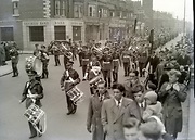
Donated by Hartlepool Museum ServiceThe camera would be about where the Central Library now stands looking along York Road. The bank is on the corner of Thornton St. Going north along the block is Heslop and Thompson, a bakery(possibly Kemp?) Bruce Moore, Find it Out and the church is York Road Methodist Church.
The photo is from the early 1950s.
More detail » Robert Adwick Thornton St
 Donated by Frances Wilson
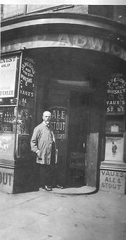
Dated 1910
Robert Adwick outside his off licence in Thornton St about 1910. The shop was on the corner of Bell St and Thornton Street and a landscaped garden is there now.
More detail » Swainson Street looking north from Thornton Street
 Created by West Hartlepool Council
Part of the Library collection
Created by West Hartlepool Council
Part of the Library collectionDated 1956
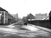
Looking along Swainson towards Grand Hotel and Raby Road in the background. The house in Thornton Street nearside left is Thornton House (on plaque on wall) Behind the fencing on the right is Messrs F Hills and Co Stockton Street Sawmill and Timber Yard. Binns is just visible on far right.
The photo was from a photographic record of the Central Area of West Hartlepool prepared in 1955/6 at the request of the Town Planning and Redevelopment Committee 'in the hope that it will be of interest to future generations of West Hartlepool'
The record focuses on areas which were within the next ten years to be completely redeveloped following The Max Lock Plan. It was compiled by WL Taylor and photographs developed by Thomas Clarkson Chemist of Tower Street.
More detail » Thornton Street 2
 Created by Douglas Ferriday
Part of the Library collection collection
Created by Douglas Ferriday
Part of the Library collection collectionDated 1966
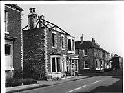
Just before complete demolition in 1966 the view is of Thornton Street. Across the bottom of the street is probably Swainson Street and the two streets off on the left are likely to be Peckett Street and closer Wesley Street
HO4100
More detail » Thornton Street and Peckett Street/Wesley Street
 Created by Elizabeth Law
Donated by Elizabeth Law
Created by Elizabeth Law
Donated by Elizabeth LawPart of the Hartlepool Museum Service collection
Dated 1965
Taken by Elizabeth Law in 1965, the style of housing looks very much like Thornton Street and the street facing the camera most likely to be Peckett Street or Wesley Street. The area was demolished in 1967 to make way for the shopping centre.
More detail » Thornton Street demolition/ Middleton Grange site
 Donated by Robert Wood Collection
Part of the Hartlepool Museum Service collection
Dated 1967
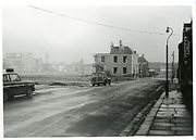
On this 1967 image, the section of Thornton Street to the east of York Road has almost gone and the area left is virtually that on which Middleton Grange Shopping Centre was built. As the photo shows, the houses were not slums but quite substantial homes.
Stockton Street had at this point to be demolished and can be seen running along in the distance. The shopping centre was built so that the back of Binns was incorporated into it.
More detail » Thornton Street from York Road
 Created by West Hartlepool Council
Part of the Hartlepool Library Collection collection
Created by West Hartlepool Council
Part of the Hartlepool Library Collection collectionDated 1956
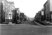
Looking east from York Road, Penzance Street is off to the left after the chapel. In the distance is Swainson Street.
The photo was from a photographic record of the Central Area of West Hartlepool prepared in 1955/6 at the request of the Town Planning and Redevelopment Committee 'in the hope that it will be of interest to future generations of West Hartlepool'
The record focuses on areas which were within the next ten years to be completely redeveloped following The Max Lock Plan. It was compiled by WL Taylor and photographs developed by Thomas Clarkson Chemist of Tower Street.
More detail » Thornton Street looking towards Clifton Avenue
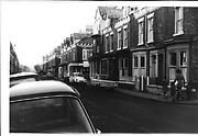 Part of the Library collection collection
Although the left hand side of the street has been renovated, the houses on the right were demolished around the turn of this century and a small park is in their place. Dyers Off licence occupies the same shop as Adwick's on an earlier photo on the corner of Bell St.
More detail » Thornton Street looking towards York Road
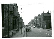 Part of the Hartlepool Museum Service collection
This is the lower part of Thornton Street looking towards York Road. The shop on the corner of York Road and Thornton Street is just visible with the white brickwork on the side.
Penzance Streeet is the street off to the right. The large building on the right at the end of Penzance Street was possibly Providence Strict Baptist Chapel originally but appears to be a home on this picture.
More detail » Thornton Street looking west from Swainson Street
 Created by West Hartlepool Council
Part of the Hartlepool Library Collection collection
Created by West Hartlepool Council
Part of the Hartlepool Library Collection collectionDated 1955
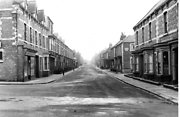
The image looks towards York Road and in the distance Clifton Avenue. Earnshaw's Bakery is on the left and Peckett Street is the street off to the right.
The photo was from a photographic record of the Central Area of West Hartlepool prepared in 1955/6 at the request of the Town Planning and Redevelopment Committee 'in the hope that it will be of interest to future generations of West Hartlepool'
The record focuses on areas which were within the next ten years to be completely redeveloped following The Max Lock Plan. It was compiled by WL Taylor and photographs developed by Thomas Clarkson Chemist of Tower Street.
More detail » Tin Boxes Factory Bomb Damage
 Donated by Hartlepool Museum Service
Dated 1940
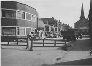
The factory opened in 1927 in Thornton Street. This shows the side of the building after being bombed in an air raid on 21 July 1940. The premises of Cecil M Yuill, Builder, is to the right of the view.
More detail » Tin Boxes Factory Bomb Damage
 Donated by Hartlepool Museum Service
Dated 1940
Workmen start to clear the site after the factory was bombed during an air raid on 21 July 1940.
HHT&N 44
More detail » York Road/ Thornton Street
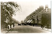 Part of the Hartlepool Museum Service collection
The road off to the left and right is Thornton Street. The left side still exists and the shops are still there wheras the large house on the right is demolished and the Yorkshire Bank, Shopping Centre ramp and Central Library are approximately where the east part of Thornton Street ran down to meet Swainson Street.
More detail »


