 Hartlepool Sports & Leisure
- Cinemas, Theatres & Dance Halls
- Musicians & Bands
- At the Seaside
- Parks & Gardens
- Caravans & Camping
- Sport
 Hartlepool Transport
- Airfields & Aircraft
- Railways
- Buses & Commercial Vehicles
- Cars & Motorbikes
- The Ferry
- Horse drawn vehicles
 A Potted History Of Hartlepool
- Unidentified images
- Sources of information
- Archaeology & Ancient History
- Local Government
- Printed Notices & Papers
- Aerial Photographs
- Events, Visitors & VIPs
 Hartlepool Trade & Industry
- Trade Fairs
- Local businesses
- Iron & Steel
- Shops & Shopping
- Fishing industry
- Farming & Rural Landscape
- Pubs, Clubs & Hotels
 Hartlepool Health & Education
- Schools & Colleges
- Hospitals & Workhouses
- Public Health & Utilities
- Ambulance Service
- Police Services
- Fire Services
 Hartlepool People
 Hartlepool Places
 Hartlepool at War
 Hartlepool Ships & Shipping

Elwick Road
Details about Elwick Road
Elwick Road, Hartlepool.
Location
Related items :
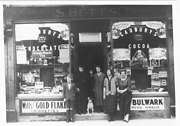
 Betts Grocers c1920
 Donated by Douglas Ferriday
Part of the Hartlepool Library Service collection
Picture of S. Betts grocer shop taken in the 1920s. Shop located in Elwick Road. Presumably the family posing outside the shop.
More detail » Briarfields
 Part of the Library collection collection
Dated 1990
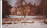
The photo was taken in the 1990s. For many years Briarfields was an old men's home but has recently been converted into luxury flats. The area where the photo was taken was for many years up until the mid 1960s the sports field for the Girls' High School in Eldon Grove
HHT+N 77
More detail » Elwick Road Junior Girls 1st year 1959
 Donated by Douglas Ferriday
Dated 1959
Elwick Road Junior Girls 1st years 1959.
More detail » Elwick Road School
 Donated by Doreen Holdforth
Dated 1935
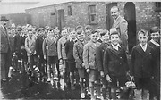
Picture of boys from Elwick Road School, Hartlepool taken in 1935. Cuthbert (Sonny) Holdforth is 6th in from the right discounting the boys in the back row.
More detail » Elwick Road School 1972
 Donated by Douglas Ferriday
Part of the Hartlepool Library Service collection
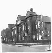
Elwick Road School 1972
More detail » Elwick Road School 1999
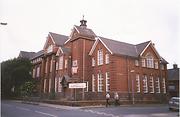 Created by John Davies
Donated by John Davies
Created by John Davies
Donated by John DaviesDated 1999
Just prior to demolition, the photo was taken looking towards the boys department. Senior boys were upstairs and junior boys downstairs. The girls' department at the far end of the building was exactly the same. At this point, the school had been part of the 6th Form College.
More detail » Elwick Road School from rear 1999
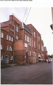 Created by John Davies
Donated by John Davies
Created by John Davies
Donated by John DaviesDated 1999
Taken in 1999 at the rear of the school the boys department was to the left, the girls to the right.
The playground did, until it was part of the 6th Form College, have a brick wall to separate boys and girls and,certainly in the 1960s and before, children were often reprimanded for talking to the opposite sex through the gate. The additonal brickwork above the Boys and Girls rear entrances were added circa early 1950's for the Senior Boys Headmaster and the Senior Girls Headmistress
More detail » Elwick Road Shops (1)
 Part of the Library collection
These shops were on the block between Flaxton Street and Charlotte Street and are shown on a colour photo just before demolition.
G Fearn was a gents' hairdresser.
HHT&N 225
More detail » Elwick Road Shops (2)
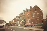 Part of the Library collection collection
Taken just prior to demolition, this block of shops was on the block between Flaxton Street and Charlotte Street on the right of the photo. The shops on the block between Flaxton Street and Osborne Road still exist.
More detail » Elwick Road back street
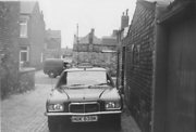 Donated by Hartlepool Museum Service
Elwick Road back street showing a Cussons taxi parked there. Lansdowne Road in the background.
More detail » Elwick Road near junction with Wooler Road
 Donated by Hartlepool Library Service
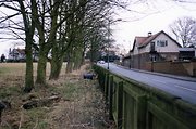
Elwick Road near junction with Wooler Road. Woodlands is on the left, now a housing estate, and the ambulance station, now closed, on the right.
HHT&N 352
More detail » Greystones 1964
 Donated by Douglas Ferriday
Part of the Hartlepool Library Services collection
Dated 1964
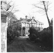
A partial view of this lovely house taken from the driveway. Greystones is a Grade11 listed building situated in Elwick Road.
More detail » Payne's General Dealer
 Donated by Mr. David Payne
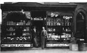
After working at CMEW at the turn of the 19th century, Samuel Charles Payne opened a General Dealers shop in Corporation Road, (Old) Hartlepool. Around 1930 he moved to a larger shop in Elwick Road. This photograph shows his sons Edward George Payne (right) and Howard Charles Payne standing in the shop doorway.
More detail » Rosebank School 1964
 Donated by Douglas Ferriday
Part of the Hartlepool Library Services collection
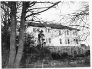
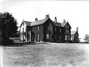
A view of Ambleside Manor as part of Rosebank School from the Burn Valley 1964.
More detail » Rosebank as a private house
 Donated by Douglas Ferriday
Part of the Library collection
Dated 1900
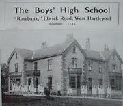
Probably taken around 1900, Rosebank at this point seems to be a private house when compared to the cover from 1934 school prospectus.
HHT&N 74
More detail » Rosebank as a school
 Created by Rosebank School
Taken from school prospectus from early days as a private school.
More detail » St Matthew's (Church) Community Centre
 Created by Don Stephenson
Donated by Don Stephenson
Created by Don Stephenson
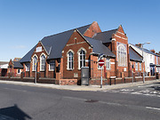
Donated by Don StephensonSt Matthew's Community Centre, Elwick Road. Church Hall for All Saints Church, Stranton.
More detail » St Matthew's Hall
 Part of the Hartlepool Museum Service collection
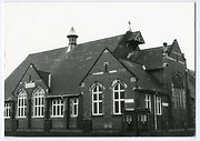
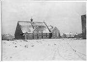
The parish hall of All Saints Stranton Church
More detail » St Matthew's Hall circa 1903
 Donated by Douglas Ferriday
Part of the Hartlepool Library Collection collection
The image seems to have been taken from Powell Street or Bangor Street possibly as the houses were about to be built indicated by the terrain. On the left, the back of houses in Arncliffe Gardens can be seen. The wall on the right is the corner of a shop. However, the buildings to the right of St Matthew's are a mystery as no current buildings seem to have that roof shape.
Can anyone help ?
HHT&N 611
More detail » Stranton Floods 1900
 Donated by Douglas Ferriday
Part of the Hartlepool Library Service collection
Dated 1900
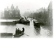
The view looks up Elwick Road and on the right behind the wall is Greenbank, once the home of JW Cameron. Waldon Street is on the right after the wall and across Elwick Road in front of the large building which is now Stranton Social Club. The terrace of houses on the right is Bathgate Terrace, Elwick Road and beyond them on the right is Holt Street, Kilwick Street and then York Road.
The quite regular floods, although a nuisance, were obviously quite an attraction.
HHT+N 36
More detail » T.M. Stonehouse
 Donated by Hartlepool Museum Service
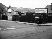
T.M. Stonehouse at the junction of Elwick Road and Osborne Road.
More detail » View of Elwick Road circa 1954
 Created by Aerofilms
Part of the Hartlepool Museum Service collection
Created by Aerofilms
Part of the Hartlepool Museum Service collectionDated 1954
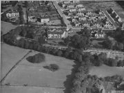
The two large houses in the foreground looking over the Burn Valley Gardens, are Ambleside on the left and Rosebank on the right and these formed Rosebank School. The large white house on the top left on the Elwick Road/ Queensberry Ave corner is Hartdale which is still there today although it is divided into two homes. The large white house top centre was Broomhill home of the Forslind family. This house was demolished in 1970 and a number of bungalows occupy the site.
Newlands Ave is the road in the centre running vertically and Westlands, Northlands, Eastlands, Southlands Avenues can be seen having been built after WW2. Claremont Drive can be seen but is very incomplete and only the first few houses built for RAF (Army ?) personnel are apparent on the top right.
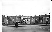
More detail » York Road Houghton Street
 Part of the Library collection
The image has been taken probably in the late 1950s from the traffic lights in Elwick Road looking towards York Road. Where the advertising hoardings are now is Shotton's Furniture Store.
In World War 2 following a bombing raid, 31 houses in Elwick Road and Houghton Street were demolished here.
In the background on the left is the tower of Stranton Club and the chimney is probably that of Durham Paper Mills.
The adverts are for Walls Ice Cream, Guiness, Players cigarettes, Double Maxim beer, Fairy, Trex and the Empire Theatre where the main act was The Merry Magpies.
More detail »


