 Hartlepool Sports & Leisure
- Cinemas, Theatres & Dance Halls
- Musicians & Bands
- At the Seaside
- Parks & Gardens
- Caravans & Camping
- Sport
 Hartlepool Transport
- Airfields & Aircraft
- Railways
- Buses & Commercial Vehicles
- Cars & Motorbikes
- The Ferry
- Horse drawn vehicles
 A Potted History Of Hartlepool
- Unidentified images
- Sources of information
- Archaeology & Ancient History
- Local Government
- Printed Notices & Papers
- Aerial Photographs
- Events, Visitors & VIPs
 Hartlepool Trade & Industry
- Trade Fairs
- Local businesses
- Iron & Steel
- Shops & Shopping
- Fishing industry
- Farming & Rural Landscape
- Pubs, Clubs & Hotels
 Hartlepool Health & Education
- Schools & Colleges
- Hospitals & Workhouses
- Public Health & Utilities
- Ambulance Service
- Police Services
- Fire Services
 Hartlepool People
 Hartlepool Places
 Hartlepool at War
 Hartlepool Ships & Shipping

Powlett Road
Details about Powlett Road
Powlett Road, Hartlepool
Location
Related items :
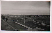
 Easington Road/Powlett Road roundabout 1949
 Donated by Robert Wood Collection
Part of the Hartlepool Museum Service collection
Dated 1949
Looking northwest from the south side of Powlett Road looking at the roundabout which opened in October 1948. Easington Road is on the left and the BISF (steel or 'tin' houses as they were known when they were quickly constructed after World War 2) can be seen.
Winterbottom Avenue is the road off to the right on the roundabout and at the time was still called Raby Road until 1967. The former line of Howbeck Lane is a path in the centre.
More detail » Gas Works Powlett Road
 Donated by Douglas Ferriday
Part of the Library collection
Dated 1965
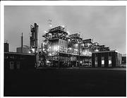
Taken in 1965 just after they were opened, the number 2 Gasworks in Powlett Road.
HHT&N 831
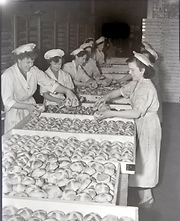
More detail » Making Hot Cross Buns 1
 Created by NDM
Donated by Hartlepool Museum Service
Created by NDM
Donated by Hartlepool Museum ServiceAt the busy Co-op Bakery around 1954.
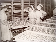
More detail » Making Hot Cross Buns 2
 Created by NDM
Donated by Hartlepool Museum Service
Created by NDM
Donated by Hartlepool Museum ServiceTaken around 1954 at the busy bakery in Powlett Rd.
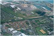
More detail » Marina and Dyke House
 Donated by Hartlepool Library Service
Marina and Dyke House from the air. Dyke House School bottom right of picture. Lancaster Road and Powlett Road also in the picture.
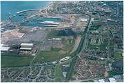
More detail » Marina and Dyke House (2)
 Donated by Hartlepool Library Service
Marina and Dyke House from the air. Lancaster Road and Powlett Road in the picture.
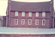
More detail » Powlett Hotel
 Created by W Henderson
Donated by W Henderson
Created by W Henderson
Donated by W HendersonPart of the Hartlepool Public Houses collection
The Powlett Hotel, Powlett Road, Hartlepool. An unusual bow fronted public house which has now closed and been converted in to shops.
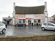
More detail » Powlett Hotel 2014
 Created by Don Stephenson
Donated by Don Stephenson
Created by Don Stephenson
Donated by Don StephensonPart of the Hartlepool Public Houses collection
The Powlett 2014. The Powlett has now been closed and converted into shops.
More detail » Powlett Road Bridge
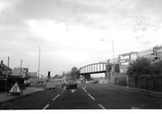 Donated by John Parsons
Dated 1994
Powlett Road Bridge before its replacement in 1994. This bridge was used by Covered Hopper (Covhop )Wagons hauled by diesel to Steetley.
More detail »


