 Hartlepool Sports & Leisure
- Cinemas, Theatres & Dance Halls
- Musicians & Bands
- At the Seaside
- Parks & Gardens
- Caravans & Camping
- Sport
 Hartlepool Transport
- Airfields & Aircraft
- Railways
- Buses & Commercial Vehicles
- Cars & Motorbikes
- The Ferry
- Horse drawn vehicles
 A Potted History Of Hartlepool
- Unidentified images
- Sources of information
- Archaeology & Ancient History
- Local Government
- Printed Notices & Papers
- Aerial Photographs
- Events, Visitors & VIPs
 Hartlepool Trade & Industry
- Trade Fairs
- Local businesses
- Iron & Steel
- Shops & Shopping
- Fishing industry
- Farming & Rural Landscape
- Pubs, Clubs & Hotels
 Hartlepool Health & Education
- Schools & Colleges
- Hospitals & Workhouses
- Public Health & Utilities
- Ambulance Service
- Police Services
- Fire Services
 Hartlepool People
 Hartlepool Places
 Hartlepool at War
 Hartlepool Ships & Shipping

Easington Road
Details about Easington Road
Easington Road, the A1086. A main road into and out of Hartlepool through the collieries.
Location
Related items :
 Easington Road
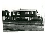 Part of the Hartlepool Museum Service collection
B.I.S.F.houses in Easington Road built in 1946 close to St Thomas More church which would later to be built to the right. More B.I.S.F. homes can be seen in Howbeck Lane behind these.
B.I.S.F. meaning British Iron and Steel Federation and the homes were emergency factory made homes put up all over the country after WW2. The majority still exist, although many much renovated and are noted for their strength.
More detail » Easington Road/Powlett Road roundabout 1949
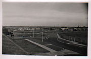 Donated by Robert Wood Collection
Part of the Hartlepool Museum Service collection
Dated 1949
Looking northwest from the south side of Powlett Road looking at the roundabout which opened in October 1948. Easington Road is on the left and the BISF (steel or 'tin' houses as they were known when they were quickly constructed after World War 2) can be seen.
Winterbottom Avenue is the road off to the right on the roundabout and at the time was still called Raby Road until 1967. The former line of Howbeck Lane is a path in the centre.
More detail » St Thomas More Roman Catholic Church
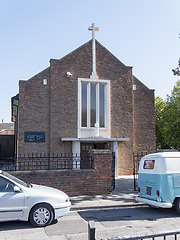 Created by Don Stephenson
Donated by Don Stephenson
Created by Don Stephenson
Donated by Don StephensonSt Thomas More Roman Catholic Church, Easington Road, Hartlepool
More detail » The Queen
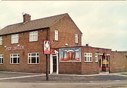 Created by W Henderson
Donated by W Henderson
Created by W Henderson
Donated by W HendersonPart of the Hartlepool Public Houses collection
The Queen Hotel, Easington Road, Hartlepool. Building now demolished to make way for flats.
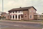
More detail » The Saxon
 Created by W Henderson
Donated by W Henderson
Created by W Henderson
Donated by W HendersonPart of the Hartlepool Public Houses collection
The Saxon public house, Easington Road, Hartlepool. Public house on an outlying Hartlepool estate.
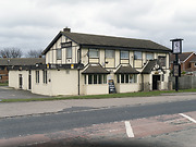
More detail » The Saxon 2014
 Created by Don Stephenson
Donated by Don Stephenson
Created by Don Stephenson
Donated by Don StephensonPart of the Hartlepool Public Houses collection
The Saxon, Easington Road, Hartlepool
More detail »


