 Hartlepool Sports & Leisure
- Cinemas, Theatres & Dance Halls
- Musicians & Bands
- At the Seaside
- Parks & Gardens
- Caravans & Camping
- Sport
 Hartlepool Transport
- Airfields & Aircraft
- Railways
- Buses & Commercial Vehicles
- Cars & Motorbikes
- The Ferry
- Horse drawn vehicles
 A Potted History Of Hartlepool
- Unidentified images
- Sources of information
- Archaeology & Ancient History
- Local Government
- Printed Notices & Papers
- Aerial Photographs
- Events, Visitors & VIPs
 Hartlepool Trade & Industry
- Trade Fairs
- Local businesses
- Iron & Steel
- Shops & Shopping
- Fishing industry
- Farming & Rural Landscape
- Pubs, Clubs & Hotels
 Hartlepool Health & Education
- Schools & Colleges
- Hospitals & Workhouses
- Public Health & Utilities
- Ambulance Service
- Police Services
- Fire Services
 Hartlepool People
 Hartlepool Places
 Hartlepool at War
 Hartlepool Ships & Shipping

Henrietta Street
Details about Henrietta Street
Street in the Throston area of the Headland which ran between Milbank Road and Frederick Street. Part of it remains but with newer housing.
Location
Related items :
 Henrietta Street (1)
 Part of the Hartlepool Museum Service collection
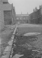
This very old image is of Henrietta Street and the reverse says the Milbank Crescent end. The building on the left is possibly the Brunswick Brewery which was in Henrietta Street.
More detail » Henrietta Street (2)
 Created by unknown
Donated by Hartlepool Library Service
Created by unknown
Donated by Hartlepool Library ServiceHenrietta Street was in the Throston area of Hartlepool. The image is looking north From Milbano Crescent towards Frederic St at the top. Only the right hand side of the street had houses and the building on the left was a factory. It belonged to Price's Tailors until it was demolished around 1960.
This is one of a number of images believed to have been compiled by Hartlepool's Planning Department.
More detail »
 Henrietta Street (3)
 Created by unknown
Donated by Hartlepool Library Service
Created by unknown
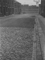
Donated by Hartlepool Library ServiceHenrietta Street, Throston ,Hartlepool, looking south Towards Milbank Crescent and the docks. The coal staithes leading to Victoria Dock can be seen with an engine on them.
Further into the background, the distinctive Central Marine crane can be seen. This is one of a number of images believed to have been compiled by Hartlepool's Planning Department.
More detail »


