Hartlepool Sports & Leisure
Hartlepool Transport
A Potted History Of Hartlepool
Hartlepool Trade & Industry
Hartlepool Health & Education
Hartlepool People
Hartlepool Places
Hartlepool at War
Hartlepool Ships & Shipping

Related items :
 Peckett Street
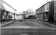 Created by West Hartlepool Council
Part of the Hartlepool Library Collection collection
Created by West Hartlepool Council
Part of the Hartlepool Library Collection collectionDated 1956
Thornton Street looking west from Swainson Street
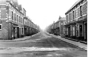 Created by West Hartlepool Council
Part of the Hartlepool Library Collection collection
Created by West Hartlepool Council
Part of the Hartlepool Library Collection collectionDated 1955